


TAP questions

What is a TAP?
A Thames Access Point is a recognisable location, well signed and clearly indicated on maps, where visitors may find easy access to the river and its amenities.
What do I need to do to get a TAP installed?
Click here to download our latest action checklist (PDF format)
Where did the idea come from?
The TAP concept originated with the goals of the River Thames Alliance, as expressed in the Thames Waterway Plan. The plan calls for various means of making the river more accessible and enjoyable by the public.
The visit Thames website has done an excellent job in promoting the river as a destination, but visitors (mostly those unfamiliar with the river) have great difficulty locating a good point to find the riverbank and start exploring.
So what will the TAP programme achieve?
- The TAP programme will create a number of specific locations along the river where easy access is possible. Each TAP will have car parking or public transport nearby.
- TAPs will then become reference points for river tourism shown on maps, trails, marketing documents etc.
- TAPs will also be used by River Thames partners and businesses, to assist them to market their products / services / facilities.
Where are the TAPs to be located?
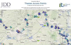
All the appropriate sites have been identified and they are all referenced through a map (click here). This surveying and mapping was funded by The Waterways Trust.
All the chosen sites are close to either a car park, a bus stop or a railway station. There are between 50 and 60 identified sites, including about 15 at lock locations. One or two further sites have been suggested since the publication of the list and map, and these are being evaluated.
What will a TAP look like?
Click here to go to the 'designs' page
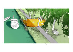
The conceptual designs for the riverside installations have been visualised by Russ Canning & Company, landscape architects. Funding for this design work was provided by The Waterways Trust.
The basic requirements as set out in the brief to the Landscape Architects were these:
- A TAP is designed primarily to welcome and orientate those who are unfamiliar with the river, although all river users will appreciate its facilities.
- A TAP should give a sense of arrival: visitors may have journeyed to find the river, and at the TAP should help them to feel that they have arrived at a destination that is attractive and welcoming.
- A TAP should be a relay point: as well as giving a sense of arrival, the TAP should also help visitors to feel that there is much more to explore, e.g. local places to see and things to do by or near the river. In particular, the TAP will sign up routes that link to other TAPs and nearby locks, or circular routes that will bring them back to this starting point.
- A TAP should be distinctly recognisable, though not obtrusive in the landscape. The recognition might come from a common architectural feature such as a beacon, flag or sculpture. It may be appropriate to specify a selection of materials that may be used, to take account of the wide variation in local landscape character up and down the river.
- Some TAPs may be at the rivers edge, some set back from the river, and some may even be floating pontoons or landing stages.
- Locks are the most obvious examples of a consistent architectural / engineering style that has been applied up and down the length of the river. The more accessible locks already perform the function of TAPs to some extent. The use of consistent interpretation signage will help to cement a feeling that locks and TAPs are all part of the same network.
- A TAP installation might include places to sit and linger or picnic, or to board a boat. There may also be interpretation boards highlighting the locality, and signposts for important local facilities. Provision should be made for the inclusion of riverside safety equipment such as lifebelts.
- Brand values for the River Thames have been identified, and the design of the TAP should be consistent with these.
- The TAP should be generally vandal-proof.
Prototypes
We are now looking to identify the first few sites for Thames Access Points. A number of riverside businesses have already expressed interest. It is expected there would initially be 5-6 prototype installations.
Rollout
Ultimately, some 50-60 TAPs may be commissioned. For each one, the following will be required:
- agreement of the EA, the landowner and the local council
- approach signing for motorists, cyclists and pedestrians (according to a specified scheme which we have documented);
- identification of a sponsor to fund the content, fabrication and installation of the sign;
- individualisation of the TAP design for the specific locality;
- finalisation of sign content (text and illustrations);
- fabrication and installation.
We want a TAP what do we need to do?
For more information, contact the TAP Scheme consultant, John Sherlock